
Lake Ontario: What Google Maps would do if it respected international law
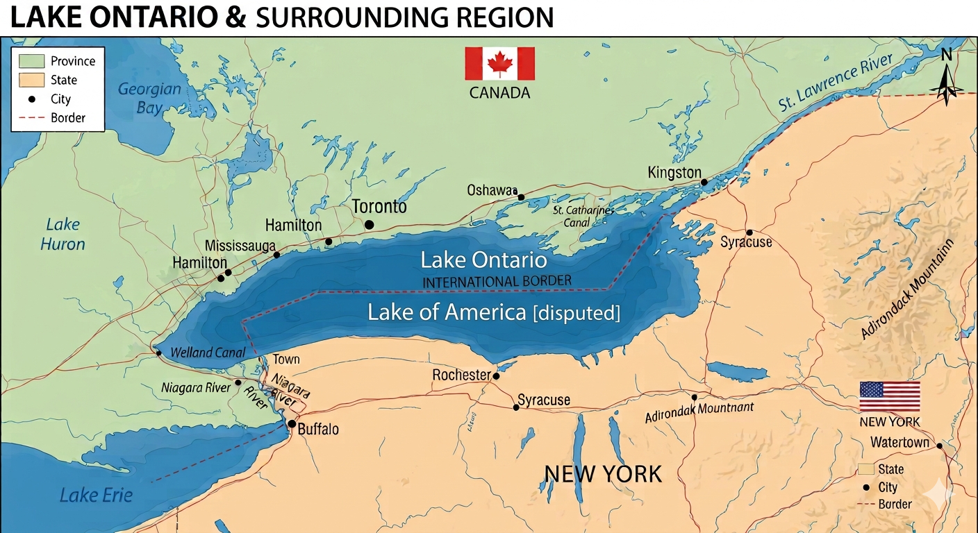

In an era where digital mapping platforms function as the de facto
arbiters of global geography, the boundaries and names displayed on our
screens carry immense geopolitical weight. A single algorithmic
adjustment or database update can reshape how millions of people
perceive national sovereignty. However, a map should reflect established
legal realities and bilateral treaties, not the unilateral declarations
of an individual government. If technology giants like Google Maps
truly respected international law, their rendering of shared
geographical features would adhere strictly to long-standing legal
frameworks rather than aligning with political edicts.
The
core issue rests on a fundamental pillar of global order: the principle
against extraterritoriality. A sovereign nation’s laws, regulations,
and executive powers stop precisely where its borders end. When United
States President Donald Trump issued an executive order attempting to
rename Lake Ontario to "Lake America," that decree legally encountered a
hard stop at the international boundary dividing the lake. Under
international law, one nation cannot unilaterally dictate the
nomenclature or status of a geographic resource shared with a
neighboring sovereign state.
Therefore,
any renaming implemented by digital cartographers must be rigorously
confined within the recognized borders of the enacting country. When
dealing with a shared body of water where bordering nations do not agree
on a name change, the map must explicitly reflect that lack of
consensus. The correct cartographic protocol under international law is
clear: any non-consensus name applied to a shared entity must be
restricted to that country's side of the boundary, accompanied by the
designation "[disputed]" to signal that the nomenclature lacks bilateral
agreement.
By
failing to restrict these naming changes to their proper sovereign
jurisdictions, mapping platforms risk legitimizing extraterritorial
overreach. It is time for digital mapmakers to align their platforms
with international law, ensuring that shared waters remain accurately
represented rather than rewritten by unilateral decree.
A History of Cartographic Aggression and Boundary Friction
To
understand why the "Lake America" directive is so problematic, one must
look at the long history of boundary friction between Canada and the
United States. While the two countries boast the longest undefended
border in the world, that line was not drawn peacefully, nor has it been
free from semantic and territorial combat. Historically, whenever
Washington has attempted to wield its cartographic weight unilaterally,
it has threatened the delicate legal equilibrium between the two North
American neighbors.
The earliest disputes date back to the foundational gaps of the 1783 Treaty of Paris,
which established the original boundary lines using vague geographic
markers. Because early surveyors lacked precise charts, vast swathes of
land became flashpoints for conflict. In the late 1830s, the Aroostook War—a
bloodless but highly volatile confrontation over the lumber-rich
territories between Maine and New Brunswick—demonstrated how easily
ambiguous boundaries could bring both nations to the brink of military
conflict. It ultimately required the 1842 Webster–Ashburton Treaty to settle the northeastern border through rigorous bilateral compromise rather than executive fiat.
Similarly, the 1859 Pig War in the San Juan Islands showcased the dangers of unilateral interpretation. Triggered by the ambiguous wording of the 1846 Oregon Treaty,
both British-Canadian and American authorities claimed sole
jurisdiction over the archipelago. Rather than allowing one side to
bully the other into a new status quo, the dispute was referred to an
independent international arbiter—Kaiser Wilhelm I of
Germany—highlighting that shared geographic disputes require neutral,
lawful resolution, not domestic political pressure.
The Shadow of the Alaska Boundary Dispute
The most poignant historical parallel to today's cartographic overreach is the Alaska boundary dispute of 1903.
Following the Klondike Gold Rush, the exact maritime and coastal
boundaries between the federal district of Alaska and British Columbia
became intensely contested. The United States, led by President Theodore
Roosevelt, used aggressive diplomatic pressure and explicit military
posturing to enforce its preferred interpretation of the coastline.
When
a six-member tribunal was assembled to resolve the issue, the British
representative sided with the American commissioners to secure U.S.
geopolitical favor, effectively outvoting the Canadian members. The
resulting loss of territory deeply traumatized the Canadian psyche,
serving as an early lesson in how major powers use diplomatic leverage
to override geographic fairness. It was this very betrayal that
catalyzed Canada’s determination to secure full treaty-making autonomy,
culminating in the 1931 Statute of Westminster, which ensured Great Britain could never again trade away Canadian geographic integrity.
Unresolved Waters and Modern Precedents
Even
today, five major maritime boundaries remain formally unresolved
between Ottawa and Washington. From the salmon-rich waters of the Dixon Entrance in the Pacific Northwest to the energy-dense continental shelf of the Beaufort Sea in the Arctic, both countries maintain distinct, overlapping legal claims. In the Atlantic, the tiny Machias Seal Island
remains a "grey zone" where both Canadian and American lobster
fishermen operate under conflicting national assumptions of sovereignty.
Crucially,
despite these ongoing disagreements, neither country has historically
resorted to renaming these shared zones by unilateral executive command.
When the United States disputes Canada’s claim that the Northwest Passage
constitutes internal Canadian waters, Washington does not unilaterally
erase the name from international charts; it registers its legal dissent
through established international channels.
The Onus on Digital Cartography
President
Trump’s domestic mandate to force the U.S. Board on Geographic Names to
adopt "Lake America" is a domestic political maneuver born from recent
trade frustrations. Legally, it binds federal agencies, but it holds no
water internationally. For over 400 years, dating back to Indigenous
Wendat roots long before the existence of either modern state, this body
of water has been known as Ontario.
When
corporate entities like Google Maps blindly ingest federal data sets,
they effectively export domestic political warfare onto global screens.
If Google chooses to map the world responsibly, it must implement strict
algorithmic safeguards for shared international spaces. On the northern
side of the international boundary line, the water must remain clearly
labelled Lake Ontario. On the southern side, if the platform must
display the American federal designation, it is legally obligated to
downsize the text and affix the word [disputed] directly beside it. To do otherwise is to abandon cartographic accuracy in favour of geopolitical compliance.

Comments
There are 0 comments on this post